Here, there, everywhere. We have to call it something, don't we? Who's got an idea? Let's call it Toponymy.

11.12.2007

Rubber's Boomtown


De haven van Manuas, originally uploaded by elinegijs.

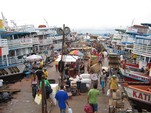
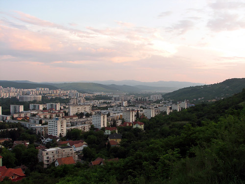
Deep in the middle of the Amazon Jungle there is a city named Manuas. Situated near the confluence of the Negro and Amazon rivers Manuas acts as a transportation hub for the interior of South America. Founded to keep Spanish armies from floating into the Portuguese mainland but it later became wealthy because of the rubber trade.

Rubber trees naturally occur throughout the Amazon rain forest. Latex rubber can be extracted from trees in a way that is similar to gathering sap from maple trees. Although colonists and native South Americans knew about latex rubber there were few good uses for the sticky substance until 1844. In that year Charles Goodyear developed the first vulcanization process, this would lead to the now common brand of tires. By 1879 industries began exploring and extracting rubber from the Amazon.


The fundamental fact that explains Brazil’s entry into and domination of natural rubber production during the period 1870 through roughly 1913 is that most of the world’s rubber trees grew naturally in the Amazon region of Brazil. The Brazilian rubber industry developed a high-wage cost structure as the result of labor scarcity and lack of competition in the early years of rubber production. Since there were no credit markets to finance the trips of the workers of other parts of Brazil to the Amazon, workers paid their trips with loans from their future employers. Much like indenture servitude during colonial times in the United States, these loans were paid back to the employers with work once the laborers were established in the Amazon basin. (source)

Manuas was named after the original inhabitants of the area, the Manaós. In their language the word means "mother of God," ("Mãe de Deus" in Portuguese) an idea that would certainly conflict with the Catholic colonists setting up this new town. If the rubber boom had not occurred it is unlikely that any other wealth would have come into the area. Manuas' landmarks such as the Teatro Amazonas could never have been built without rubber money.

The rubber boom died out around the 1920s when industrialists discovered that rubber could be grown and harvested at a lower cost in Malaysia, Sri Lanka, and Africa. At this time synthetic blends of rubber also became prevalent reducing the amount of actual latex rubber needed for many rubber products.

10.24.2007

No Toro, Más Dinero

Sometime next year Barcelona will have its last scheduled bull fight. The city once was home to three bullrings, Plaza de el Torin (demolished), Plaza de las Arenas (closed in 1977), and the Plaza de Toros Monumental

These massive stadiums were designed for the "national spectacle" of bullfighting. However, many Catalans consider bullfighting a tradition that is "too Spanish." The Monumental has announced that it will hold the last scheduled bullfight in the city sometime next year.

Architect Richard Rogers has signed on to a 100 Million Euro project to transform the dilapadated Plaza de las Arenas bullring into a shopping destination. Catalans and tourists alike can now shop for shoes and CDs on the very soil where matadors and bulls danced to the death.

10.22.2007

Sri Pada, Adam's Peak


Shadow, originally uploaded by MaxxG.

No other mountain in the world is revered by as many different religions as Sri Pada. It is known as Al Rohoun to Arabs, Svargarohanam to Tamils, and Adam's Peak to English speakers. Even before Bhuddists arrived at Sri Pada (or any part of Sri Lanka, the island south of the Indian peninsula) the mountain had religious significance. An ancient and mysterious footprint was carved into rock near the mountain's peak. Abrahamic religions interpreted this as Adam's footprint, Bhuddists see it as a mark left by Bhudda himself during one of his many journeys to Sri Lanka.

Thirty miles of tiny islands seperate Sri Lanka from India. While geologists, oceanogaphers, and historians cannot agree on the age of the formation, most agree that it is a man-made structure. Hindus call it Rama's Bridge after the popular epic hero of Hinduism. Westerners typically refer to it as Adam's Bridge in order to tie together the region's religious metaphors. The water is typically shallow between these limestone islands (rarely greater than 30 feet) - this would presumably have aided human movement between India and Sri Lanka.

The Indian government has started a dredging project through the narrow and shallow strait. Although people have opposed the project on religious and environmental grounds their objections fell on deaf ears. It is officially known as the Sethusamudram Shipping Canal Project.

10.20.2007

Retracing the footsteps of Alexander


This BBC documentary attempts to follow in the "Footsteps of Alexander" (the Great, as he is known in the West). You can watch the entire thing on YouTube.

The two "webisodes" above highlight Alexander's truly earth-changing force. The island city of Tyre resisted his authority in 332 BC. Alexander ordered his army to build a causeway from the mainland to the Phonecian city (in modern Lebanon). The earthworks took seven months but had the desired effect. Alexander took over the city and essentially attached it to the shore. The 6/10 mile long road collected silt from sea currents and transformed the island city into a peninsular city.

Another video in this series discusses the Egyptian city of Alexandria far more eloquently than I can. Many cities throughout the Middle East and Central Asia bear his name. This map shows where a few of them are located.

10.19.2007

A Tale of Two Monuments


spire, originally uploaded by Peanut99.

The wedge on the right part of that photo is not an errant needle. It is the Dublin Spire, officially known as the "Monument of Light." At 400 feet tall this stainless steel spike punctures the skyline of a mostly horizontal city.

What is truly spectacular about the Spire is that it stands on the site of Nelson's Pillar. An IRA bomb demolished the top part of the Pillar in 1966 - nobody was hurt or killed by the blast. In fact, many Irish seemed happy that the monument to their British colonial past had suffered such a blow. Several folk-style songs, such as Up Went Nelson, commended the bombers and quickly rose to the top of the Irish radio.

One early morning in the year of 'sixty six,
A band of Irish laddies were knocking up some tricks,
They thought Horatio Nelson had over stayed a mite,
So they helped him on his way with some sticks of gelignite.

While the Spire has its own share of detractors, it is not nearly as unpopular as its predecessor. There is no "visitors center" or other means of interpretation on the site. A coil of metal at street-level is said to signify prehistoric Celtic megaliths. Beyond that the site is entirely void of description. As Witold Rybczynski says, the Spire "gains its power from its engineering, rather than from symbolism."

10.13.2007

Rule of the East


Vladivostok Station., originally uploaded by chimpsonfilm.

The Vladivostok Terminal of the Trans Siberian Railway is an elegant structure. It is eight time zones and several days' journey away from it's opposite terminus.

9.07.2007

8-Bit Graffiti


does this really need a title?, originally uploaded by Bernat_83.

Fixed-width, or monospace, fonts wouldn't exist if not for the invention of the typewriter. While many people claim to have invented the first typewriter it was first manufactured in Central New York. L.C. Smith, Corona, and Morse Chain Company were among the first to build typewriters for the general public.

Manual typewriters used these fixed-width fonts to simplify the key-to-print machinery. These fonts were adopted by early word processing programs and redrawn to for dot-matrix printers.

Nostalgic feelings run deep for these digital relics such as this Graffiti example, ASCII, and other 8-bit art.

9.05.2007

Factories of Art


dafen, originally uploaded by lila75.

The gates to the village of Dafen are marked by this giant sculpture. Dafen has gained international fame and noterity as a hub for art reproductions. Cribbing works like the Mona Lisa requires a great deal of technical skill.

In vast studios Dafen's artists create their reproductions in an assembly line fashion. Each artist adds only a few brush strokes, ones that he or she has perfected. The end result is a stunningly high quality painting that is difficult to differentiate from the original.

Dafen is located outside Shenzhen, a large Chinese city near Hong Kong. Each year more artists flock to the village. Spiegel estimates that over 5 million oil paintings come out of Dafen each year.

9.04.2007

Australia's Meeting Place: Canberra


Nighty Sky in Canberra, originally uploaded by OzBandit.

The largest and best known planned city in Australia is its capital: Canberra. Around 1900 Aussies debated whether to put the capital in Sydney or Melbourne, the two largest cities on the continent. Since it was located between the two cities Canberra was picked as a compromise in 1908. Currently it is the largest inland city in Australia.

The name of Canberra comes from the Ngunnawal and Walgalu tribes who inhabited the area. It translates to "meeting place." The nomadic tribes gathered around present-day Canberra to meet the annual Bogong moth migration.

"As the moths migrate southwards, their world collides with human society. Their route, followed for thousands of generations past, now passes over the bright lights of Canberra and other large cities. The lights fool the moths into behaving as if the sun is coming up. Their natural response is to dive down to the ground to find a dark place before the heat of the day sets in, and suddenly there are moths everywhere."
Bogong moths travel over 900 miles during their short lives. The aboriginal Australians met the moth flock every spring to feast on them. According to anthropologists the moths were mashed into a pasty meal that tasted like walnuts. The giant swarm of moths is critical for the ecosystem of the Australian Alps; they are a food source for many animals.

The design of Canberra was selected from an international competition in 1911. Chicago architect Walter Burley Griffin along with his partner and wife, Marion Mahony Griffin won the contract. Both had worked for Frank Lloyd Wright. The influence of his prairie style and the City Beautiful movement is evident in their designs.

8.29.2007

Jeepney


Jeepney, originally uploaded by Raphael Borja.

At least one resident of Manila is sick of his city's portrayal in popular media. Carlos Celdran, a tour guide in Manila, expressed his anger at outsiders who come to the Philippines in search of only poverty, slums, and desperation. In response to a photographer searching for Manila's "bat people" he wrote,

" I have always been so confused about why is it that the negative side of Manila is what a lot of photographers and journalists are interested in. My request to these people in the past to show a balanced picture of Manila (a good side, as well as a bad one), has always been met with confused stares. It's as if Philippine middle class values, arts, heritage, and beauty in the "normal" sense isn't beautiful to them or worse, it won't sell. To many, the Philippines has become the cliche/easy picking for the grotesque and I will not enjoin this cause. Once again, my apologies if I offended you or seem a little politicized or upset, but poverty and bat people is NOT ALL that we are about." (via MetaFilter)
The photograph above is a "Jeepney." At the end of World War II, the American military abandoned hundreds of jeeps on the main island of the Philippines. Lavishly decorated and often crammed full of passengers these vehicles act like buses on the streets of Manila.

The name "Manila" derives from the Tagalog word "maynilad", a reference the white mangrove-like plants named "nilads". Spanish conquistador Miguel López de Legazpi took over Manila in 1570 ousting the Muslim Sultanate that originally settled it. Since that time the city had been under the control of the British and Americans before gaining independence in 1946.

8.26.2007

Korea's Ginseng Market


/root - IMG_1040, originally uploaded by jeroen020.

The Latin name for the ginseng plant is Panax which means "all-heal." Carl Linnaeus, the man responsible for all those Latin names, had heard about the reported healing attributes of ginseng as the Chinese applied it. Since then the plant has become a staple of the alternative-medicine market. Ginseng boosters claim that the plant is effective against conditions as diverse as diabetes, male impotence, allergies, and cancer.

Because the actual chemical components of the ginseng plant cannot be patented for pharmaceutical purposes not much quantitative research has been preformed on its effects. Nevertheless many people in the East and West believe in the healing effects of ginseng. Some extremely wealthy Koreans are willing to pay many thousands of dollars for rare, wild ginseng plants.

The New York Times just reported that a 8.3 ounce ginseng plant sold for $65,000. The person who discovered the Lexus-of-plants claimed to have a spiritual experience before finding the plant on Mt. Sobaek, seeing "three pillars of fire." The struggling South Korean economy has driven many people into the mountains searching for the elusive root-plants.

The picture above is of Namdaemon market in Seoul, South Korea. Ginseng roots are preserved in jars and left on display for the market's patrons.

8.25.2007

Seven (Several) Seas

One of the categories of Anna Sova's online color pallets (for wall finishes) is called "7/10 of the planet." The description goes on to list the seven seas of classical antiquity:

  • Red Sea
  • Mediterranean Sea
  • Persian Gulf
  • Black Sea
  • Adriatic Sea
  • Caspian Sea
  • Indian Ocean
Curious about which cartographer coined the term I started to do some research. While I'm not trying to criticize the marketing staff at Anna Sova (who, in my opinion, have done a fantastic job of cataloging their many color options!) they might be a bit off about their listing.

At least four ancient nations described "seven seas," Hindus, Chinese, Persians, and Romans all called various bodies of water by this ambiguous name. The Romans dubbed the seven salty lagoons surrounding Venice such; the Hindus used it for the Punjab River; the Persians did the same for the Oxus River. This begs the question: why always seven?

Seven is held up as a sacred number by people around the world. There are seven days in a week, seven deadly sins, seven wonders of the world, seven "naked eye" solar bodies. Some people even suggest that seven is analogous to several: the use of the number seven might be a way of acknowledging the vast and unpredictable nature of water.

Rudyard Kipling might be responsible for the modern usage of the term. In 1896 he titled a collection of poems The Seven Seas. Nevertheless,
modern attempts to mold the oceans of the world to the number seven seem contrived (dividing the Atlantic Pacific into North and South, for instance).

8.24.2007

The Polar Bear Memorial

You won't find it in Arkhangelsk, the location of the "campaign." It's in Troy, Michigan, a suburb of Detroit. Allied commanders decided to deploy soldiers to Arkhangelsk after the conclusion of World War I. Their justification for this superbly dumb expedition was to defeat the Bolshevik armies and rejoin with the Czech Legion.

Fifteen hundred infantrymen from Michigan and Wisconsin were sent to fight over some of the coldest and most inhospitable terrain in the Northern Hemisphere. They joined an additional thirty five hundred British and French soldiers along the Murmansk coast; facing the White Sea and the Arctic Ocean. Their mission proved to be futile and directionless. Extreme cold, a shortage of supplies and the Spanish Flu combined with their unclear objectives deteriorated the troops morale.

After several public calls to bring "Detroit's Own" back home Woodrow Wilson (and the other Allied commanders) decided to pull the plug on the "Polar Bear Expedition." By the early summer of 1919 the soldiers began to return. It would take another ten years for the Russians to return the remains of the American dead. The Polar Bear Memorial in Troy has a quote from Stephen Decatur engraved on its base: "Our Country, in her intercourse with foreign nations, may she always be in the right; but our Country, right or wrong."

8.23.2007

The Great Lake of Cambodia


Reflection of living, originally uploaded by siggito.

High in the Chinese Himalayas the Mekong River begins its long journey to the sea. Parts of the river are strongly affected by the tropical climates of Southeast Asia. Melting snow combined with monsoons bring the river and its tributaries far beyond their dry season banks.

In Cambodia this torrential rain reverses the Mekong's flow. The water fills in the Tonlé Sap, or "Great Lake." During the dry season the small, marshy basin is at most around 3 feet deep. At the peak of the wet season the lake grows to six times its surface area and over sixty feet deep.

Less ingenious people might think of this region as uninhabitable. Cambodians, however, have built homes, businesses, churches and whole towns in the Tonlé Sap area. The house pictured above is designed to float with the rising waters. Other buildings are built on tall stilts (some over 30 feet tall).

Furthermore, the Tonlé Sap is a critical part of the region's economy. The lake/river water is ideal for fish breeding. Cambodians harvest shrimp, riel, and many other kinds of seafood from the pulsing lake.

8.19.2007

City on Fire


Urbanity, originally uploaded by Piax.

Last Summer the conflict along the Israel-Lebanon border drew the world's attention. Hezbollah militants provoked Israel into launching a full scale war against its northern neighbor. Unexploded cluster bombs in southern Lebanon remain after the month-long war. These places remain abandoned for fear of unexpected detonations.

Although most of the fighting took place near the border, Lebanon's largest city and capital was also bombed by Israeli forces. The ancient city that modern Beirut is built over was poorly understood until archaeologists returned following Lebanon's 15 year civil war. They uncovered layers of Ottoman, Roman, Phoenician, and Hellenistic civilizations.

8.15.2007

How did we get here?

Which of these is closer to reality? Which is more fun to watch?


I can't give you the answers. You have to decide for yourself. Via Great Lakes Guy and Paleo Future
.

7.27.2007

America's Moving Adventure


Fly Fishing, originally uploaded by champy1013.

I love U-Haul's slogan for its ambiguity. The reference to moving either implies hauling your junk across the country in an automobile or trailer or being emotionally moved by some unnamed force.

I will be on the move next week so posting will be light. Above is a picture of where I'm moving: Ithaca, New York.

Yes, it's very gouda!


Market Square, Woerden, originally uploaded by groggy doggy.

Of the four cheese markets in the Netherlands only the one in Woerden is authentic. Here, dairy farmers who produce cheese set the sale price with a market foreman (marktmeester) in an open setting. The other three cheese markets (kaasmarkt) are historical reproductions for tourists. They are located in the cities of Alkmaar, Edam, and Gouda.

The Gouda you find at the grocery store did not come from Gouda in the Netherlands unless it says "Noord-Hollandse Gouda." The European Union has strict standards on how place names are used on food labels. Strangely, the city of Gouda is not located in North (Noord) Holland, but South Holland - somebody should alert the PDO/PGI/TSG.

7.26.2007

Buried Treasure, c. 1914


DSC_2153, originally uploaded by ichimusai.

Southern Europe is cited in countless history books as the fuse that ignited World War I. Macedonia (also called F.Y.R.O.M.) was under the control of the Central Powers during the war. The French army fought throughout the area. Joined by British and Serbian forces they attempted to repel Austrian, German and Bulgarian armies.

Fifteen years ago a farmer near Gradesnica (a town in Novaci, Macedonia) happened upon some old glass bottles. According to the Independent,

The cases appear to be dotted all over Gradesnica, like bones buried by dogs. One cache was unearthed by farmers plowing their fields. Two more were found when a glint of metal in the sand of an old trench caught one farmer's eye.

The cases were filled with wines and cognacs from World War I. French connoisseurs are paying enormous sums for these rare and spectacular bottles of cognac (the wine has gone bad, apparently). A bottle was recently sold for 5,000 euros. (via Chow)

Macedonia is negotiating for the use of its name. The dispute between Greek Macedonians and ethnic Macedonians ignites passions but doesn't generally affect the commerce and cooperation between the two nations. Greek Macedonians want to keep the name "Macedonia" for their provinces which go by the same name. They believe that it would be incorrect to allow Slavic Macedonians the exclusive use of the name. The Greeks want their neighbor to be called the Former Yugoslav Republic of Macedonia (FYROM). The dispute is in negotiation through the United Nations.

The city pictured above is the capital of Macedonia (FYROM), Skopje. Greeks use this name to refer to the entire nation in order to avoid confusion with their Macedonian province. Linguists would say that the Greeks are using a "metonym."

7.24.2007

Iran in Pictures


Yazd, panoràmica (2), originally uploaded by Sebastià Giralt.

The infamous autocratic regime running the Iranian government would like to have a total monopoly on photography. Nevertheless, last month the Iranian Flickr group celebrated their one-year anniversary. In spite of the national internet provider blocking flickr.com, these dedicated Iranians have been posting pictures of their nation for thirteen months now.

The city pictured here is called Yzad. Around a half-million people call this Central-Asian city home. Yzad is named after a Sasanian King who ruled in the beginning of the 5th century. Yazdegerd I, as he was called, was apparently a terrible leader, one account says this of him,

When he consolidated his power, he so greatly belittled the nobility oppressed the weak and shed so much blood that his subjects prayed to God to end his tyranny. He earned the epithet "the Sinner"

In the current asymmetrical, image-centric conflict, Iran's citizens might be gaining an upper-hand. Recently created webpages claiming to show Iran have "gone viral" in attempts to show what Iran really looks like.

Check the previous Toponymy post on The Fire Temple or Agiary to learn more about Zoroastrianism and the religious history of Central-Asia.


7.23.2007

Wadi al-Hijarah


GDL, originally uploaded by fritztroid.

Mexico's "Second City" in terms of population and business activity is Guadalajara. It takes its name from the city in Spain located in Castile-La Mancha. The literal translation of Guadalajara is "River of Stones" from the Arabic phrase: Wadi al-Hijarah.

Spanish Guadalajara was occupied by the Roman empire, however, all physical evidence of their presence has vanished. As the Islamic caliphate spread across the Iberian peninsula it established hundreds of new settlements. An "alcazar" or fortress was built at Guadalajara, and some of its ruins remain. Even though Islamic settlers did not found Mexican Guadalajara, the name is still rooted in Arabic.

This picture shows the Hospicio Cabañas, a hospital for orphans, elderly, handicapped, and chronically ill people. Built in the early 1800s it is a massive and simple building. It is home to several works by Mexican muralist José Clemente Orozco. UNESCO has designated it a cultural World Heritage Landmark.

7.18.2007

8th Continent


morondava, originally uploaded by stephaneu_06.

Peter Tyson coined this nickname for Madagascar in the title of his ecologically-oriented book. The enormous number of species endemic to Madagascar draw biologists from around the world. Many distinct varieties of flowering plants, lemurs and chameleons of any color can be found only here. These species survive on Madagascar because of its isolation from other continents.

The central highlands and plateau divide the narrow island's East and West regions. Tropical forests are found mostly along the East coast while the West remains drier. This topography prevents plants and animals from inhabiting the whole of the island.

Geologists speculate that Madagascar is one of the oldest islands (having been separated from Africa for some 88 million years). That long period of time has allowed the fauna plenty of time to adapt to the special circumstances of their environment. It is also long enough that evidence of prehistoric creatures such as the Elephant Bird.

The Malagasy people have as fascinating story as their non-human neighbors. The island was settled between 1,800 and 1,500 years ago by Austronesian explorers from Indonesian islands. Sturdy boats and fast currents brought the Austronesian people from their home waters to places as far flung as Easter Island. Around the same time settlers from mainland Africa first discovered it.

The trees pictured above are known as Baobabs, and yes, this variety is found only on Madagascar. You can see them in the daylight and at sunset.

7.17.2007

The Story of Booger Mountain

I was going to title this post Unusual and Derogatory American Toponyms, but it just didn't feel right.

A ten minute segment on Weekend America pondered the significance of strange place names. Reporter Kelly McEvers investigated a small Illinois town named Goofy Ridge. According to local accounts it was dangerous, filled with meth-addicts, and really backwards. The "official account" of the origin of Goofy Ridge's name can be traced to a time when men in the area shot walnuts off one-another's shoulders (a la William Tell).

According to the sociologist interviewed here, the factual and truthful reason for Goofy Ridge's name is less important than how listeners respond to hearing an outlandish story. In his framework, toponyms like Goofy Ridge are applied by more powerful groups onto their weaker neighbors.

The second half of the segment is a discussion with Gary Gladstone, a photographer who sought out American towns with bizzare names (such as booger mountain). A gallery of his work is available online, you can go from Idiotville, Oregon to Tightwad, Missouri.

If you would like to listen to the segment you have two options. Download the MP3 [24.9MB] and start at the 31 minute mark. Or go to the Weekend America page and use Real Player.

7.16.2007

Getting Around, Asia


Getting Around, United States


Previously, the Detroit People Mover.

Port


Rabelo boats - II, originally uploaded by Vitor Rodrigues.

The city of Oporto, Portugal lies at the mouth of the Douro river. In the green and steeply sloped valleys of this river the grapes for Port wine grow. Port is known as a fortified wine which means additional alcohol has been added to kill yeast and prematurely end the fermentation process.

Port wine owes its name to the Roman Empire. The settlement on the Douro river was called "Portus Cale" by the Roman armies who discovered it. Cale referred to the Celtic people who lived in the area.

The boats in this picture are Rabelos. They are the traditional river boats used to carry barrels of Port down the river to Oporto.

7.13.2007

The Spaceport of our Dreams

Brought to you by Plan59 via Paleo-Future.

7.12.2007

There's No Rio in Rio


rocinha, originally uploaded by Priya Papriiika.

Rio de Janeiro translates to "January River" in English. However, there is no river in Rio, only a large bay. Portugese explorers found the bay on the twentieth of January, 1502 (and added Rio because that was a word used for any large body of water). When the city was founded some 63 years later it was officially named, São Sebastião do Rio de Janeiro 20, after Saint Sebastian.

The photographer who took the above picture describes life in the city's favelas. These improvised buildings surround Rio and many other Brazilian cities, housing the poorest city dwellers. She describes the situation,

As for the real dangers of the favela, that would just be crossfire between the military police and the dealers or between two rival dealers. It’s pretty much a daily thing, so it’s not really any major deal for the regular people who live there.

The Brazilian government has recently announced plans to invest $1.7 billion to improve living conditions in the favelas. That money is expected to bring running water, street lighting, hospitals and schools to these neighborhoods.

Rio de Janeiro's statue of Christ the Redeemer made the cut in the recent 7 Wonders poll. Completed in 1931 it's the newest of the "new 7" and one of three located in Central or South America.

7.11.2007

Mysteries of Toponymy Solved!

The Springfield of Bart, Lisa, Homer, and Marge is in Vermont. Throughout the series, writers have offered few clues to the location of Springfield. There are over 50 towns and cities named Springfield in the US.

Springfield Vermont won the video contest put on by USA Today. You can watch all the videos online. The small city received more votes than its total population. As a result of its victory it will host the premier of The Simpsons Movie on the 27th.

3D Spaces: Raster vs. Vector

It's difficult to verbally express how potent SketchUp is as a modeling tool. I think this video does an excellent job of showing how simply and seamlessly SketchUp can capture a real form in a digital format.

Compare that to Laser Scanning. The costs and intense software needed to interpret the "point cloud" generated by a laser scan make it unrealistic for the general public.

via Digital Urban.

7.10.2007

Inukshuk


Resolute Inukshuk, originally uploaded by davebrosha.

At the Bruce Peninsula National Park visitors center a small sign was posted telling people not to build Inukshuk. Parks Canada defines Inukshuk as "an Inuit stone cairn having the rough outline of a human figure." But the word can be more closely translated to English as, "something which acts for or performs the function of a person."

As far as I can decipher these rocky monuments are visual landmarks for the inhabitants of arctic Canada. The barren landscape and unusual solar activity make land navigation difficult. Inukshuk are markers that help Inuit and other arctic peoples orient themselves.

Part of the reason for this rock person craze is the Vancouver 2010 Olympics. The official logo is an Inunnguaq: "imitation of a person" built out of boulders, it is a more rare type of Inukshuk. Vancouver's Olympic organizers have dubbed their mascot Ilanaaq, the Inuit word for "friend."

6.29.2007

Ringstraße des Proletariats

This Viennese residence spans just over 1 kilometer (.68 miles) making it the longest continuous housing structure in the world. Not unlike Chicago's Hancock Tower, the building contains many of the amenities that its denizens need: kindergartens, doctors' offices, and a library. From a different perspective you can see the arches under this massive building that allow traffic to pass through it.

Karl Marx Hof is an example of a Gemeindebauten: municipal building (like public housing in the U.S.). The fortress-like construction of these buildings made them durable and also ideal for use by the military. Karl Marx Hof played an important part in Austria's February Uprising in 1934.

When I was in Vienna I got on a bus near Karl Marx Hof. Once I saw these pictures I immediately remembered having seen these enormous arches.

6.28.2007

Sea Gypsies

The Moken People anticipated the 2004 Tsunami that crushed Sri Lanka and Thailand. I mentioned them in an earlier post, but now (through the magic of YouTube!) we can have a look at this fascinating society.


6.27.2007

Atlas Underground


Time lapse video of the construction of the Atlas experiment at CERN. The underground particle accelerator will be the largest ever constructed, and perhaps the most complex experiment in the history of science.

6.26.2007

Estonia Unexpected


Tallinn, originally uploaded by Tashi Delek.

Helsinki's neighbor across the gulf is on its way to become the celebrity nation of post-communism. When compared to other former Soviet states, Estonia rated at the top of the heap in terms of economic and individual freedom, corruption, and human development. Furthermore, Estonia ranked at the top globally in the composite index State of World Liberty.

While other former Soviet states have devolved into despotism and disorder, Estonia has nurtured the growth of a legitimate, representative government. Most of the nation's trade goes through Nordic states with historic and cultural similarities. Iceland was the first nation to recognize the independent Estonia after the final Soviet forces left.

Soviet withdrawal from the Baltic states was precipitated by the longest human chain ever created. Around 2 million people held hands across Estonia, Latvia, and Lithuania, it reached over 370 miles. The deteriorating remains of the Soviet military installations in Estonia are easy to find. So called, "ghost bases" that many native Estonians weren't aware of until the departure of the Soviet military are beginning to attract tourists interested in the history of nuclear warfare and communism.

Have a look at Tallinn's old city hall and an inviting street cafe.

6.25.2007

The Land God Made in Anger


Namibie_Skeleton_Coast_02, originally uploaded by calips96.

Namibia's northern coast has been called many names. Portuguese sailors who happened upon the foggy, super arid shore called it the "Gates of Hell." The coastal area is extremely dry since winds come out of the East and not from the ocean. If that weren't enough the heavy surf makes it nearly impossible to launch a dinghy from the beach. Beached survivors faced an unforgiving march through one of the driest places on earth.

Those unlucky sailors soon learned why the native people of Namibia called this "The Land God Made in Anger." Now it is known as the Skeleton Coast after the bones left behind from hundreds of shipwrecks caused by this treacherous sea.

Ecologists study the area for two reasons: it's inhospitality to life, and the enormous seal colony that comes ashore at Cape Cross.

6.22.2007

Our Three Dimensional History

We've all thought at one time or another, "what would it be like to walk around in London in 1616?" Thanks to CANOMA and SketchUp, now you can!


The effect is more pop-up book than true visualization. But imagine what we might learn about ancient civilizations,


military history,


and cities buried under new development.


Via Digital Urban.

6.21.2007

Virtual Landmark, II

An automated email replied to the Royal College of Art's suggesting that Google Maps add a temporary marker for their 150th anniversary exhibition at the Kensington Gardens. After a week and a half of apparent inaction the college took matters into their own hands.

They decided to install their own marker in the appropriate location.


See the original Virtual Landmark.

6.20.2007

Incarceration Postcard

Before Uncle Jimmy tires to bust out of the clink he might try to get in touch. If he's in the Michigan State Prison at Jackson he can do just that with this handy postcard. (He could even circle his cell in red marker!)

As I understand it, Jacksoners refer to the prison by its address on Cooper Street. Of all of Michigan's prisons, the Jackson facility is located in the most urbanized area (it is also likely the largest concentration of correctional facilities in the state, followed by Ionia).

The political implications of prison location are somewhat interesting. It seems that prisons tend to be placed in rural areas where they artificially boost the population. This website shows examples in Michigan, New York, Ohio, and lots of other states. Furthermore, it looks like the number of prisons (and prisoners) has escalated dramatically in the past 20 or so years. Investigating further into New York I discovered that the state has a maximum security facility solely for women.

*Old News: San Pedro in La Paz, Bolivia; where inmates pay to rent their cells with money they earn in the prison's economy

6.19.2007

Ramblin' Man

Last.fm has made my workday fly by. Splicing together thousands upon thousands of people's musical tastes it quickly picks out songs I (usually) enjoy like some kind of personalized DJ. For instance, here is a selection of songs labeled Ambient, where I discovered the Ramblin' Man.

After I heard Lemon Jelly's Ramblin' Man I rushed to find a freebie download of the song to post here. But, as far as Google knows, there is no free version of the song. The lyrics list out 67 places where the singer has visited. The only Continent that isn't included is Antarctica.

You can listen to a few other Lemon Jelly songs online such as, 76 (Stay With You), Nice Weather for Ducks, and Sim Time.

*I had toyed with posting this annoying video as an example of Toponyms in popular media, but I couldn't bring myself to watch it for more than 10 seconds.

Late Addition: The songs don't work. So in their place have a look at the rivers and lakes hiding under Antarctica.

6.18.2007

We are Tuna


Tsukiji Fish Market, originally uploaded by x-girl.

And we're all just waiting around at the Tsukiji Fish Market in Tokyo. Around 1972 Japanese fish wholesalers discovered the delectable taste of the Bluefin Tuna when caught in the seas near New England. American fisherman didn't have a market for the giant fish so they were happy to put them on transcontinental flights to Japan.

The Tsukiji Fish Market is the largest market for seafood in the world (by area and tonnage of product). It moves around 4.4 million pounds of seafood daily. There is practically no limit to the diversity of sea creatures that are sold at Tsukiji: eel, lobster, oyster, barnacles, sea pineapples, octopuses, squid, puffer fish, sweet shrimp, and flying fish can all be found at wholesale prices.

Tuna, however, are the main event. Buyers for large distributors and single restaurants all gather at Tsukiji for the daily auction of Tuna. The stakes are high. According to Vanity Fair the buyers can lose control:

The tuna weighed 200 kilos. At ¥100,000 per kilo, the possessed bidder had paid ¥20 million—the equivalent of more than $170,000—for a fish whose parceled meat could never recoup that amount.

The tricky part about this auction is that the buyers cannot truly know the quality of the fish until it has been cut open. Clues about the texture and taste of the fish are derived from the fins.

The official name of the Tsukiji Fish Market is the Tokyo Metropolitan Central Wholesale Market. It is owned and operated by the municipal government through a law dating back to 1923. Officials in Tokyo are debating the practicalities of moving the public market to a new, larger site. Vendors and buyers seem to be adamantly opposed to the proposal since the former Tokyo Gas site has severe ground pollution.

One would imagine that a place as crowded with live and recently decesed sea creatures would posses a certian smell (putrid or gut-turning, for instance). However, according to at least two visitors it doesn't stink.

Via Vanity Fair, If You Knew Sushi, and CHOW, Sushi Scribes.

6.16.2007

The Bridge on the River Kwai

Last night I watched The Bridge on the River Kwai. I had vague memories of the film from childhood but I couldn't remember the plot.

It's rare that a piece of infrastructure takes the spotlight as singlehandedly as this bridge does. The British Colonel (Alec Guinness), through his stubbornness experiences a sort of stockholm syndrome. His crippled pride leads him to identify with his Japanese captors. His reversal is so strong that he wants to build a bridge that will stand as a monument to British ingenuity and craftsmanship. Once it's finished he sees it as the only sure thing he has accomplished in his 29 year military career.

Another topological curiosity in this film is the Japanese Colonel's initial proclamation that the labor camp was on an island. Because of this he said that escape was impossible, that this was the reason no barbed wire had been erected around the POW camp. Toward the middle of the movie a British officer reveals that this is patently false. The infamous railway is entirely in Southeast Asia, the Kwai river is in Western Thailand.

The natural landscape takes on an interesting bit part as well. The Kwai river's diminished flow; the hazards of the dense, tropical jungle; and the constant threat of heat exhaustion all pressure the non-native characters in this movie. (While the Thai women appear able to carry munitions through all kinds of terrain without breaking a sweat!)

In any event the movie is excellent. I was probably too young to appreciate it the last time I saw it.

6.14.2007

Cluj-Napoca


Our Neighbourhood, originally uploaded by sonykus.

From the photographer's description:

The oldest rows of these blocks were built in the '50s and '60s. Then, legend has it that former dictator Ceausescu once came to visit the (Atomic Physics and) Chemistry Research Institute nearby. He noticed that the whole place looked too relaxed, almost like a Spa, with decent conditions, lots of parks and green spaces between all those blocks.

He was outraged of this terrible waste of living space, and ordered a second wave of construction, starting immediately. So there came this second wave in the 70s, filling in the gaps between the older buildings with new rows of 5-story blocks, killing out most of the parks and the green lanes left. And thus, the whole thing got as crammed as you can see it today. ...


This picture was taken in a city named Cluj-Napoca in Romania. The city of 300,000 holds the title as the historical capital of Transylvania. There is some controversy about the etymology of the region that seems to fracture down lines of Latin and Hungarian interpretations. Literally translated from Latin, Transylvania means "beyond the forest."

*The city's wikipedia article lists Cluj as a sister city to East Lansing, Michigan, but I can't find any other confirmation on that.*

6.13.2007

Abandonment Enthusiasm


Brown Sugar, originally uploaded by Ride My Pony.

Although I was familiar with the idea of Urban Spelunking, I had no idea it's presence was so strong on Flickr. I've listed out a few of the pools where Flickrites can add their pictures of abandonment.

The Graffiti Project on Kelburn Castle


More on the Graffiti Project and Kelburn Castle.

6.12.2007

Infamous Address

Nazi Germany's General Foundation for Welfare and Institutional Care was located at Tiergartenstraße 4. It was the bureau responsible for the deaths of physically and mentally handicapped people in the years just before the holocaust. Germans who knew about the program as simply the T4 Action.

The building is no longer there but a plaque in the sidewalk commemorates the horrors that were mandated at the site. Hospitals throughout the nation were ordered to perform euthanasia on patients who were considered incurable. That meant the“criminally insane,” schizophrenics, epileptics, people with Huntington’s, chorea, advanced syphilis, senile dementia, paralysis, encephalitis and “terminal neurological conditions generally” (and of course "non-Aryan" patients were always welcomed by T4).

The instigators and participating physicians of the T4 action were charged in the "Doctors' Trial," one of the several trials following the major war crimes trial. 20 of the 23 defendants were medical doctors, seven were hanged.

6.11.2007

Istanbul, not Constantinople


Istanbul, Turkey, originally uploaded by balavenise.

Turkey's largest city has gone by many names. The Roman-derived name was officially dropped in 1930 by Atatürk's national reforms.

Currently, the sprawling, dual-continental city is building a rail tunnel to connect the two sides of the Bosphorus Strait. Early in the construction, however, an ancient seaport was unearthed. According to the BBC:

Just a few metres below ground, they found an ancient port of Constantinople - named in historical records as the Eleutherios harbour, one of the busiest of Byzantium.
Like Boston's Big Dig, the discovery of historical artifacts is likely to slow down the project. The tunnel is projected to open in 4 years at a cost of $2.5 billion.

Baikonur Cosmodrome


Energia Launch Site Panorama, originally uploaded by galexian.

In the vast and dry nation of Kazakhstan the Baikonur Cosmodrome remains an operational testament to the Space Race. Baikonur is the world's oldest and largest operational space launch facility. After the collapse of the Soviet Union in 1991 it continued operation in partnership with the Commonwealth of Independent States.

The Baikonur Cosmodrome is home to a tremendous amount of space exploration history. The first human spaceflight (Vostok 1) launched here as well as the first unmanned satellite (Sputnik 1). The facility was crutial for the International Space Station construction after the 2003 Columbia disaster.

Now, like so much else, the old Cosmodrome is a tourist attraction. RusAdventures offers a six day tour that departs from Moscow with your choice of English, French or German tour gides.

See an illustrated map of the facility.

6.08.2007

Destination


., originally uploaded by Tresselboard.

This airport island is located someplace in the Maldives. Even at a low altitude the photographer could capture the entire runway and habitation of this island. Without more detail it's impossible to know if it is a secret military installation or an exotic resort. The capital of the Maldives has a similar sort of picture on Wikipedia.

6.07.2007

I used to be a missile silo

And not just any missile silo, but an intercontinental ballistic missile silo.

This old ICBM silo in Albiene Texas has been decommissioned and turned into a pool for scuba diving. It was mentioned on an episode of Geo Quiz as perhaps the deepest pool on earth. (The show focuses most of its attention on the intentional pool Nemo33 in Brussels, an indoor pool 33 meters deep and 33 degrees celcius.) It's a fascinating example of adaptive reuse and demilitarization.

Listen to the MP3 Audio of the GeoQuiz.

Honey Barge


Nile, near Aswan, Egypt, originally uploaded by Zinnie.

The world's longest river flows supplies much of the life in arid Egypt. Besides transportation, water, and fish the Nile was important for beekeeping.

Migratory beekeeping began during this period [5000 years ago] as hives (in mud pots) were put on boats or rafts which sailed up and down the Nile following the honey flows, much as beekeepers in the U.S. do with 18-wheelers today

The anciently named country currently is home to around 82 million people.

[Thanks to MeFi for the inspiration and Zinnie for the image]

6.06.2007

Eccentric Spaces

Eccentric Spaces


I was excited about reading this book when I first found it on Paperback Swap. It's a strange piece to say the least. Harbison explores fictional and real spaces with emphasis not on materials and history but on the conceptual frameworks that in which we experience spaces.

Eccentric Spaces takes a gnarled journey through European painting, writing, and cities. Harbison's writing is thick and soupy in places where he gets twisted around on various tangential subjects. He succeeds when discussing the various treatments that authors of fiction (and historical fiction) give to settings.

This is truly a mysterious book that belongs in no genre. It would function well as a starting off point for architectural conjecture or urban planning debates. Nevertheless the book feels dated and too deeply European and it too often gets mired in unmanageable comparisons.

*Cross posted from A Single Step*

Strange Maps

I feel the obligation to recommend Strange Maps as an excellent source for eccentric cartography. The recent posts on the Stockholm Metro Map in English and the Inglehart-Welzel Cultural Map of the World were really spectacular.

6.05.2007

Survivalism

6.01.2007

The End of the World


Intensidad... o Lago Fagnano, originally uploaded by Any Manetta.

Ushuaia, Argentina is the southernmost city on the planet. The lonely town on Tierra del Fuego is serviced by the Southern Fuegian Railway, more popularly known as the End of the World Train. The narrow gauge railway was built to service the penal colony of Ushuaia and aid in the construction of a full prison there. The penal colony has since shut down and the train is now a tourist attraction for visitors to Argentina's southernmost lands.